 Skip to content
 Precision Farming Technologies
 At Plantations International, we make it easy to maximize productivity.
Plantations International’s Precision Farming Technologies (PFT) have been set up to make it easy for you to maximize your broadacre productivity, using the latest variable rate technology and systems.
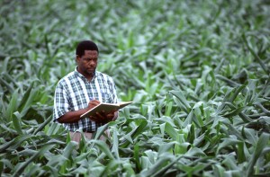
For more than 10,000 years people have cultivated crops using trial and error, received wisdom and how the soil feels when they rub it between their fingers. Only recently in history, mechanisation revolutionised the countryside with machinery and replaced horses with tractors.
Nowadays, we’re witnessing a new farming revolution triggered by the adoption of staggering new technologies: satellites, high precision positioning systems, smart sensors and a range of IT applications combined with high-tech engineering.
The latest precision farming technology may be complex, but using it doesn’t have to be. The Plantations International PFT platform allows gathering of spatial data and processing it into different paddock management zones.
These zones are typically based on how a crop may potentially perform, and when we combine this with soil and tissues tests, along with our local knowledge of the area, we can advise you on how to manage the different zones to maximize harvest yield. Using cutting-edge software, we make informed recommendations and deliver prescription files to suit the variable rate technology controller for your airseeder or boomspray.
Environmental Aspects
Precision Farming is about managing variations in the field accurately to grow more food using fewer resources and reducing production costs.
Soil, weather, vegetation, water – vary greatly from place to place. And all these factors determine crop growth and farming success. Farmers have always been aware of this, but they lacked the tools to measure, map and manage these variations precisely. Thus, Precision Farming can make a difference to food production facing the challenge of a rising world population and can help farmers to achieve;
- Greater Sustainability
- Higher Productivity
- Economic Benefits
- Environmental Protection
We’ll Help You Uncover the Paddock Within the paddock.
At Plantations International , our precision farming experts follow four steps to make it easy for you to maximize your broadacre productivity, using the latest variable rate technology.
Step 1. Acquiring and Processing Data.
A qualified Plantations International agronomist will assist you in gathering the relevant data from your paddock. This data will usually be in the form of harvest yield maps but may also be electromagnetic data, satellite or aerial imagery, or elevation data. After we’ve gathered all the data, our PFT agronomists will process it into different management zones.
Step 2. Soil and Tissue Testing Zones
Once paddock zones have been created, usually according to different nutritional requirements such as fertilizer or lime or gypsum, we carry out soil and/or tissue testing to determine the types and rates of product that are right for each zone.
Step 3. Recommendations
Plantations International agronomists analyze the data and recommend the best way to optimize the quality and yield from each zone, taking into account local conditions. We use tools such as Nutriwise®, PaddockWise© and Yield Prophet™ to ensure we give you the most informed recommendations.
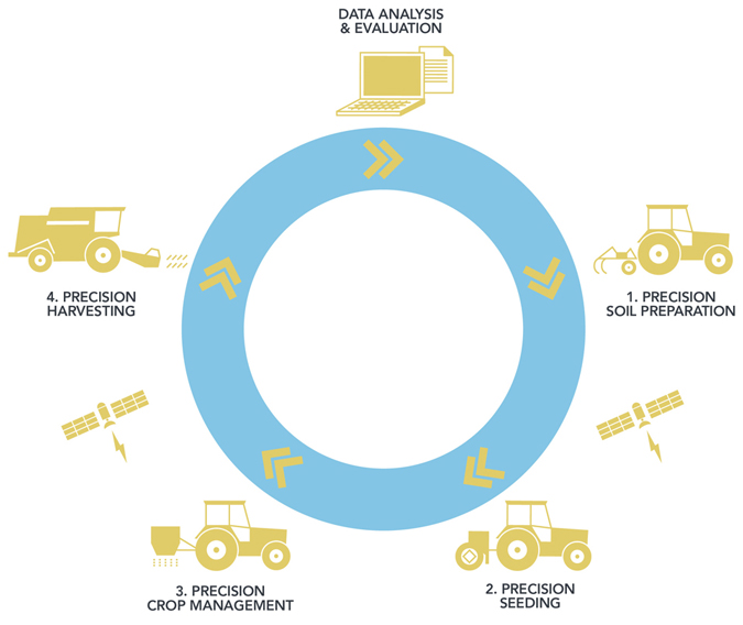
Step 4. Prescription Files
At the end of all this testing and analysis, we provide you with a prescription file that can be used on your airseeder, spreader or spray unit. The prescription file makes it easy for you to manage paddock zones and vary the inputs and products between zones.
Gathering Paddock Map Information.
Gathering good paddock map information is the key to successful variable rate applications.
We can help you gather paddock information from a number of different paddock mapping sources. When these maps are layered over one another, they help us to define zones within the paddock.
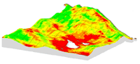 Harvest Yield Maps
Harvest yield data is generally the best information to gather. The data from the yield maps of previous harvests can be layered when defining zones and accounts for seasonal variability.
Airborne Maps
The use of airborne imagery has typically been limited because of the high cost involved, but it does have advantages in being able to reliably gather an image at a pre-designated time. Aerial imagery can give more finite detail than commonly used satellites, with resolution down to 50 centimeters. And with the cost per hectare coming down, we’re predicting that airborne imagery will become much more cost-effective in the future.
Satellite Maps
Images obtained remotely via satellites can be used to identify the variability in crop growth caused by factors such as nutrient deficiencies, disease, moisture stress, weed infestation, insect damage and weather damage. Satellites can often see what we can’t and have the ability to take images of large swaths of land when there are cloud free conditions. We have access to a number of satellites that can deliver information in a range of formats. Commonly measuring red and near infrared reflectance, a satellite image can produce a map of Normalised Differential Vegetative Index (NDVI), which can give clear pointers to parts of a crop that are stressed and parts that are healthy. These zones can then be managed on a specific basis with the variable rate application of chemicals such as nitrogen.
Electromagnetic (EM38) Soil Surveys
Electromagnetic soil surveys measure the apparent electrical conductivity (ECa) of soil. Factors such as soil moisture content, salt levels and soil texture can affect the ECa and ultimately, the crop yield. So we measure the ECa through high-resolution EM 38 surveys that involve attaching an electromagnetic sensor to a vehicle and running it across a paddock.
Elevation (Topographic) Maps
Using elevation information from yield maps or other digital sources, we can create a topographic map of the paddock. In certain regions, such as the vast dune-swale system in the South Australian and Victorian mallee, paddock topography is often associated with different soil types. In other areas a topographic map can define areas that are more prone to wind and water erosion.
Active In-Crop Sensors
Active in-crop sensors such as the Crop Circle™ and GreenSeeker™, are devices that can be mounted to a vehicle and used to create a Normalized Differential Vegetative Index (NDVI) map of a field, similar to satellite imagery. The big advantage of these devices is that they have their own light source (that’s why they have ‘active’ in their name) and can function day or night, or in overcast conditions. NDVI maps created with units like the GreenSeeker™, are commonly used for variable rate nitrogen application. The Plantations International Product Development Team has been using GreenSeeker™ technology for a number of years now and has a good understanding of the technology.
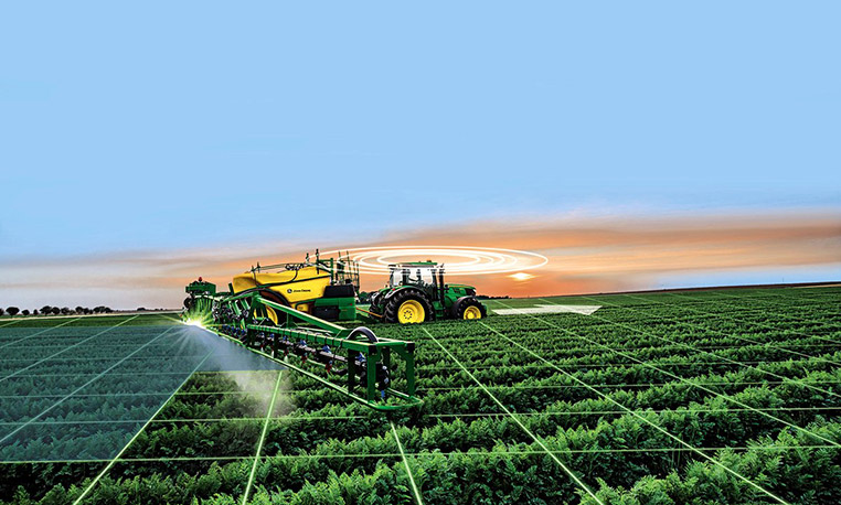
What is Variable Rate?
Typical variations can occur in a paddock in a number of ways.
- Soil types (the proportion of clay, loam and sand as well as rock, which affects moisture holding capacity).
- Soil chemistry (the pH, cation exchange capacity and organic carbon).
- Soil nutrient levels (phosphorus, nitrogen and trace elements).
- Elevation profile.
- Weed burdens.
- Disease burdens
By measuring variation across paddocks through the use of yield, elevation, biomass and soil characterization surveys, data management zones can be established. Through the use of targeted soil and tissue testing we can understand what is driving variability within a paddock and by utilizing variable rate technology, we can manage the variables effectively in order to make significant gains.
- We can better manage risk.
- We can maximize the returns from input investments.
- We can ensure long term farm and business sustainability.
And there’s no doubt that precision farming can maximize your returns. In fact, variable rate technology could give you net benefits of up to USD$300/Acre.
To find out more about the Plantations International Precision Farming Technologies and to receive a free initial consultation, please call us today on +852 5808 3775 or Click Here to contact your nearest Plantations International representative.